
Geological Mapping Services - NYC, Manhattan, The Boroughs, Nassau County, Suffolk County, Long Island, and New Jersey - Kagaoan Engineering
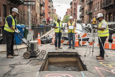
Comprehensive Geological Mapping, Repair, Remediation, Inspection, and Stabilization Services
Geological mapping is the foundation of every safe, stable, and compliant construction or remediation project. It provides engineers with a precise understanding of subsurface conditions, structural risks, and environmental factors that influence long‑term site performance. With accurate geological mapping, property owners, developers, and municipalities can make informed decisions that protect investments and ensure structural integrity.
Contact us for a free consultation.
What Is Geological Mapping?
Geological mapping is the scientific process of documenting the physical characteristics, structure, and composition of the Earth’s surface and subsurface. It identifies rock types, soil layers, faults, folds, and other geological features that influence construction, land use, and environmental stability. Geological mapping helps engineers understand how subsurface materials behave under load, stress, and environmental changes. It is essential for predicting hazards such as landslides, sinkholes, and groundwater contamination.
This mapping process also supports infrastructure planning by revealing excavation challenges and foundation requirements. Geological mapping provides a visual and analytical representation of geological conditions that impact project safety and feasibility. It is a foundational tool for engineering design, environmental protection, and long-term site stability.
When Would Geological Mapping Be Used?
Geological mapping is used during the early planning stages of construction projects to determine whether a site is safe and structurally viable. It is essential when evaluating land for residential, commercial, or industrial development. Engineers rely on geological mapping to identify subsurface risks such as unstable slopes, weak soils, or buried faults. It is used when assessing groundwater conditions that may affect excavation, foundation design, or long-term building performance.
Geological mapping is also critical for environmental remediation projects where contamination pathways must be understood. Municipal agencies use geological mapping to plan infrastructure such as roads, bridges, and utilities. It is used to determine the best locations for landfills, reservoirs, or energy facilities. Geological mapping is necessary when investigating natural hazards such as earthquakes and landslides. It is used to support mining, drilling, and resource extraction activities. Geological mapping is also valuable for forensic engineering when determining the cause of structural failures. Finally, it is used to guide stabilization and repair strategies for compromised sites.
Types of Geological Mapping
Geological mapping encompasses several specialized mapping approaches, each designed to address specific engineering, environmental, or scientific needs. These mapping types help engineers understand both surface and subsurface conditions, enabling safer and more efficient project planning. Each type provides unique insights into soil behavior, rock structure, groundwater movement, and hazard potential. Together, they form a comprehensive toolkit for evaluating complex sites and designing effective remediation, repair, inspection, and stabilization strategies.
- Outcrop or Surface Mapping — This type focuses on direct observations of exposed rock and soil formations. It documents lithology, boundaries, and visible structures to understand surface geology. Engineers use this mapping to evaluate terrain conditions and plan land-use or infrastructure projects.
- Structural Mapping — Structural maps highlight tectonic features such as faults, folds, and thrusts. They reveal subsurface deformation patterns that influence stability and seismic risk. This mapping is essential for projects in areas with complex tectonic histories or elevated seismic activity.
- Thematic Mapping — Thematic maps address specific concerns such as hydrogeology, mineral resources, or natural hazards. They integrate geological, hydrological, and environmental data to support decision-making. These maps are crucial for groundwater studies, contamination remediation, and hazard mitigation.
- Depth Mapping — Depth maps incorporate geophysical and subsurface data to illustrate deep geological structures. They show buried faults, reservoir geometry, and sediment thickness. Depth mapping is vital for geothermal projects, deep aquifer studies, and subsurface stabilization planning.
- Bedrock Mapping — Bedrock maps depict consolidated rock formations beneath soil layers. They help engineers assess the quality of foundation rock and the challenges of excavation. Bedrock mapping is essential for large structures requiring deep foundations.
- Surficial Mapping — Surficial maps focus on loose materials near the surface such as sediment, gravel, and soil. They are critical for construction planning, agriculture, and groundwater studies. Surficial mapping helps determine soil stability and suitability for foundations.
Who Needs Geological Mapping Services?
Property developers need geological mapping to ensure their projects are built on stable and predictable ground conditions. Architects and engineers rely on geological mapping to design structures that can withstand local geological forces. Municipal agencies use geological mapping to plan infrastructure projects that require safe excavation and long-term stability. Environmental consultants depend on geological mapping to understand contamination pathways and remediation needs. Utility companies require geological mapping when installing pipelines, cables, or underground systems. Insurance companies may request geological mapping to assess risk for high-value properties.
Construction firms use geological mapping to anticipate excavation challenges and prevent costly delays. Homeowners planning major renovations may need geological mapping to evaluate soil stability. Industrial facilities rely on geological mapping to ensure safe placement of heavy equipment and storage tanks. Transportation authorities use geological mapping to design roads, tunnels, and bridges. Mining and drilling companies depend on geological mapping to locate resources and avoid hazards. Legal and forensic teams use geological mapping to investigate structural failures and support litigation.
What Can Happen if Geological Mapping Services Are Not Completed?
If geological mapping is not completed, construction projects may encounter unexpected subsurface conditions that lead to structural failure. Buildings may experience foundation settlement due to weak or unstable soils. Excavation activities could trigger landslides or collapses if geological hazards are not identified. Groundwater intrusion may damage foundations or cause flooding in basements and underground structures. Contaminants may migrate unpredictably, complicating remediation efforts and increasing environmental risk. Infrastructure such as roads or bridges may fail prematurely due to undetected geological weaknesses. Repair and stabilization costs can escalate significantly when geological issues are discovered too late. Overall, the absence of geological mapping increases safety risks, financial liabilities, and long-term instability.
Why Clients Choose Kagaoan Engineering
Clients choose Kagaoan Engineering because of its deep expertise in geological engineering and subsurface investigations. The firm’s engineers are highly experienced in evaluating complex geological conditions across NYC, Long Island, and surrounding regions. Kagaoan Engineering integrates advanced geological mapping with practical engineering solutions to ensure safe and cost-effective project outcomes. Their team specializes in soil mechanics, groundwater control, slope stability, and foundation design.
Clients value the firm’s ability to provide thorough inspections, remediation strategies, and stabilization plans tailored to each site. Kagaoan Engineering also offers forensic geological services to diagnose structural failures and support litigation. Their commitment to precision, safety, and innovation sets them apart in the industry. The firm’s collaborative approach ensures that developers, architects, and contractors receive reliable guidance throughout every project phase.
Frequently Asked Questions (FAQs)
- How long does geological mapping take? The timeline varies based on site size, complexity, and required subsurface investigations, but most projects range from several days to several weeks.
- Is geological mapping required by building codes? In many regions, including NYC and New Jersey, geological and geotechnical investigations are required for safe foundation design and compliance.
- Can geological mapping identify contamination risks? Yes, geological mapping helps identify pathways for groundwater contamination and supports remediation planning.
- Does geological mapping help prevent landslides or slope failures? Geological mapping identifies unstable slopes, weak soils, and structural features that contribute to landslide risk.
- Can geological mapping be used for forensic investigations? Yes, geological mapping is essential for determining the cause of structural failures, soil movement, and groundwater-related damage.
Contact Kagaoan Engineering for a free Geological Mapping Services Consultation
Geological mapping is a critical component of safe, efficient, and compliant construction and environmental planning. It provides essential insights into subsurface conditions that influence stability, foundation performance, and long-term structural integrity. Without geological mapping, projects face increased risks, unexpected hazards, and costly remediation. Kagaoan Engineering delivers precise, science-driven geological mapping tailored to the unique conditions of NYC, Long Island, and surrounding regions.
Their expertise ensures that every project begins with a clear understanding of geological constraints and opportunities. Clients benefit from comprehensive evaluations, advanced mapping techniques, and reliable engineering guidance. Contact Kagaoan Engineering today to schedule a consultation and ensure your project is built on a foundation of geological certainty.
About Kagaoan Engineering
Kagaoan Engineering is recognized throughout NYC and Long Island for delivering precise, science‑driven geotechnical evaluations that protect structures from avoidable subsurface risks. Their team combines advanced geological mapping with decades of field experience, ensuring every project begins with accurate, defensible data.
Clients trust Kagaoan Engineering because they consistently provide clear, actionable engineering solutions that reduce uncertainty and prevent costly remediation. The firm is known for its meticulous inspections, thorough documentation, and commitment to long‑term site stability across residential, commercial, and municipal projects. Kagaoan Engineering stands out for its ability to diagnose complex soil, rock, and groundwater conditions and translate them into practical repair and stabilization strategies.